I rode 47 miles from Scotts Valley, CA (in Santa Cruz County) to San Jose, CA.
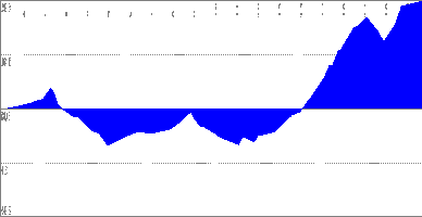
This map shows my route from Scotts Valley to Lexington Reservoir in Los Gatos, a distance of 30 miles. The elevation profile shows me starting at 500 feet, climbing to about 800 feet, dropping down to nearly sea level, climb to 500+ feet, drop back down, and then another climb to 1800 feet elevation on Summit Road.
To continue to downtown San Jose, I rode the Los Gatos Creek Trail to its terminus at Meridian Avenue near I-280 in San Jose. From Meridian, I rode San Carlos Street into downtown San Jose, then backtracked a few blocks on Almaden and Santa Clara to San Jose Diridon Station. I had to wait an hour for the Highway 17 Express Bus, so I cruised another six miles through San Jose, stopping to buy drinks, food, and a newspaper for the bus trip home.
See related:
map,
bike+route,
bike+map,
bicycle,
los+gatos,
lexington,
scotts+valley,
santa+cruz+county,
santa+cruz+mountains,
santa+clara+county,
summit+road,
san+jose,
elevation,
elevation+profile
No comments:
Post a Comment