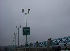
I crossed the Pajaro River into Monterey County on my bike to get to Salinas Road, which I followed around to get to Highway 1. I turned off of the highway in Castroville to catch the Monterey County bike path that runs mostly the all the way to Monterey with only a couple of short interruptions on lightly traveled back roads. The path is mostly pretty nice, though it gets annoying with multiple stop signs in Marina, Sand City and Seaside as it crosses intersections and meanders back and forth under Highway 1. This whole route so far is very doable on a fixed gear bike as it's mostly flat with rolling hills here and there. From Watsonsville to Seaside is 25 miles.
I turned onto Highway 218 (Canyon Del Rey Blvd) and then I followed all the cars and SUVs over to South Boundary Road for the steep uphill to the Laguna Seca Raceway, which averages about a 4% grade but gets to 8% in a couple of spots, which is tough with a 69 inch gear, especially after 30 miles of riding.
I rode the 33 miles from Watsonville to the Sea Otter Classic in right at two hours clock time. The next time I'll do this with my geared road bike.
For the return trip I intended to take the #27 MST bus from Marina to Watsonville, where I could then catch a commuter express back to Santa Cruz, but I missed my bus by about 10 minutes. I cheated a little because I only got as far as Moss Landing, where my wife picked me up just north of the big power plant there.
6 comments:
...bus hop or not, my admiration for your fix gear cycling exploits are no less, fritz...that's still a long crazy ride considering you went down there to "do stuff"...& to finish up riding south boundary on a fix ???...whoa !!!
...technically, you COULD ride west of the freeway from santa cruz all the way down to just south of salinas rd, then down through moss landing & onto nashua rd, which i assume the bike path crosses, but the mileage would probably be more than twice the actual distance...
...i wasn't aware of the MC bike path, which sounds mostly cool...
...anyway, fritz, to any of your readers who don't know the area, i'm letting them know you done good, my friend, you done good...
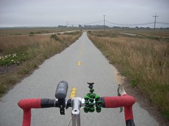
Is that a Gorillapod on your handlebars?
I was going to ask the same question as Michael. Is that setup secure enough to take pictures on the go?
South Boundary Road was tough, but the rest of the way is pretty flat so no big deal. I rode demo bikes all day also at the event.
Yep, it's the small Gorillapod. Even my tiny Nikon Coolpix camera flops over, though, when mounted on the gorillapod. I haven't lost a camera with that setup, but I have to flip the camera up before shooting a photo. Larger, stiffer versions are available.
I have a larger version of the Gorillapod for my dSLR, haven't tried it on the bike yet though.
Although for a camera mount, I made one using Instructables: http://www.instructables.com/id/Bicycle-Camera-Mount-for-under-$1/
The thing works like a charm...
This is the complete link:
http://www.instructables.com/
id/Bicycle-Camera-Mount-for
-under-$1/
Post a Comment