It's kind of an open secret among cyclists in the San Francisco Bay Area that a "Bike There" mapping option is in internal testing at Google in Mountain View. We're pretty excited about it, even if the average speed they use to calculate trip time is 8 mph.
Recently I was looking at Google Maps for Los Gatos, California when I noticed the Los Gatos Creek Trail is in Google Maps!
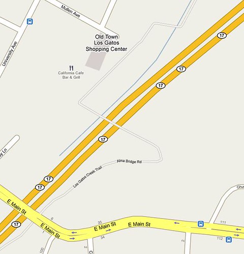
I immediately hunted around for other bike paths I know about. Coverage is spotty, even in the San Francisco Bay Area. Portions of the Stevens Creek Trail in Mountain View, for example, are missing, as is the Guadalupe River Trail in San Jose . The Oregon Expressway Bike Bridge is in Google Maps, but Ringwood Avenue is missing. The labeling of the trails is also inconsistent for now.
Elsewhere, I see trail info has been added to Boulder, Colorado but is missing from its neighbor Longmont, Colorado. (Note that the Open Street Map project map for Longmont includes the St Vrain and Lefthand Creek trails.)
Right now, the trail data doesn't seem to be used at all for directions, even when you select "Walk There," but Google says the trail data will be used and a "Bike There" option will be available Real Soon Now in Google Maps.
See also:
- Urban Velo: Google announces "Bike There" option for Google Maps.
- Bike PGH: Googles announces plan for bike there option.
Do you see trail data in Google Maps for your area? How complete is it?
10 comments:
The L A River Bike Path has been added to both google maps and gmaps.
Rock Creek Park Trail here in DC just started showing up, which means I can use the "Follow Roads" feature at MapMyRide rather than turning on the satellite view and navigating through the tree-tops. Joy!
Here's the announcement of Google's new map data, which includes some bike paths:
http://google-latlong.blogspot.com/2009/10/your-world-your-map.html
If you find a portion of a bike path that's incorrect, click the "Report a Problem" link in the lower right corner of the window. The Maps team will fix it as soon as they can.
(disclaimer: I work at Google)
Good to know about those other locations.
@Trevor - thank you.
Now, if Garmin would actually include bike paths and bridges for its GPS units...
Thank you for pointing this out.
As for the Garmin GPS comment: To do this, Garmin's data providers (TeleAtlas, NAVTEQ, whomever) need the data. The best source for this data is the organization who built the facility. And they're probably not sharing.
You can encourage the local bike facility agency to consider sharing or selling the data to the country's data providers.
@Steve - a big part of the problem also is that the data is not available in a consistent format. The street and address data was formalized years ago, but not so for paths and trails.
...marin county shows the "sausalito - mill valley" path & the "tiburon linear park" path so if you're looking for but not aware ahead of time that they were "multi-use" or bicycle paths, you'd never really learn it on google maps...
...there are also numerous other paths throughout the county that are not included...
...there is one however actually listed as a "bikeway" & that is the "sir francis drake bikeway" running parallel to sfd blvd throughout samuel p taylor park...
...it is, however, unclear as to where it actually begins on the eastern most end...
...but hey...it's all a step or a peddle stroke in the right direction...
Recently I needed a bike-friendly way to get from the Great America LRT Station to an office park on Scott Blvd in Santa Clara. I went looking on Google Maps but didn't find anything helpful. I was looking at the prospect of having to ride some extremely busy roads, until I discovered the San Tomas Aquinas Bike Trail - via the Santa Clara County Bikeways Map, and suddenly my trip turned into a fun 2.5 mile bike ride. Would be great to see info like this integrated into Google Maps
@ramkun - Funny you should mention the San Tomas Aquino Trail. All the rain flooded it and it's closed right now.
Post a Comment